GIS Consulting and Mapping
Our Environmental Mapping services provide spatial insights to drive sustainable development, climate resilience, and ecological stewardship.
- Home
- Services
Environmental Mapping
Using advanced GIS, remote sensing, and data analytics, we map land use, biodiversity, climate risks, and pollution patterns to inform urban planning, infrastructure design, and environmental policies. Our solutions support decision-making across sectors—from optimizing green spaces in cities to assessing climate vulnerability at regional scales.
With an interdisciplinary and data-driven approach, we analyze environmental trends, visualize impacts, and develop actionable strategies for mitigation and adaptation. Whether it’s flood risk mapping, renewable energy site selection, our mapping solutions help businesses, governments, and communities make informed choices that balance growth with ecological responsibility. By integrating geospatial intelligence with sustainability principles, we ensure a resilient and livable future.
- Architectural Design
More Information
Impact Analysis
At Archikaar Designs & Sustainability, our Impact Analysis focuses on understanding how environmental factors affect your project. By analyzing climate risks, resource availability, and ecological impact, we help design strategies that minimize environmental harm and enhance resilience. This assessment is key to ensuring that your project thrives within its natural surroundings while contributing to sustainability goals.
Topographical mapping
Topographical mapping is crucial for understanding the natural contours and features of a site. It provides essential data on elevation, slopes, and drainage patterns, guiding effective land use and sustainable design strategies.
At Archikaar Designs & Sustainability, we utilize topographical mapping to ensure projects blend seamlessly with the landscape while optimizing environmental impact.
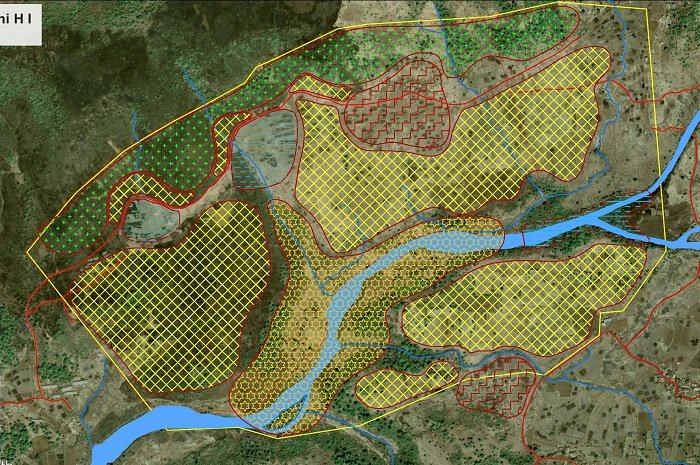
Thematic Mapping
Thematic Mapping helps visualize and analyze critical environmental factors that influence a project’s sustainability. By integrating layers of data such as land use, vegetation, climate, and resources, we create detailed maps that guide informed decision-making. This service supports strategies for optimal site planning, resource management, and risk mitigation.
Water Resource Mapping
Our services provide data-driven insights to support sustainable water management, climate resilience, and urban planning. Using advanced GIS, hydrological modeling, and remote sensing, we analyze watersheds, groundwater recharge zones, and surface water dynamics to optimize resource allocation and mitigate risks like flooding, drought, and contamination. Our interdisciplinary approach integrates environmental science, urban development, and policy frameworks to deliver actionable strategies for governments, businesses, and communities.
From mapping critical water supply networks to assessing the impact of climate change on hydrological systems, our solutions help stakeholders make informed decisions. We specialize in watershed management, stormwater planning, flood vulnerability assessments, and aquifer sustainability studies.
- Architectural Design
More Information
Hydrological Analysis
Hydrological analysis is essential for understanding water flow patterns, drainage systems, and flood risks in a given landscape.
At Archikaar Designs & Sustainability, we assess watershed dynamics, groundwater recharge potential, and stormwater management strategies to create climate-resilient solutions for sustainable water resource planning.
Watershed Delineation
Watershed delineation helps identify drainage basins, flow paths, and water accumulation zones, ensuring effective water resource planning.
At Archikaar Designs & Sustainability, we use advanced GIS and hydrological models to map watersheds, optimize stormwater management, and support sustainable development.
Drainage Mapping
Drainage Mapping helps identify natural and man-made water flow patterns to prevent flooding and optimize stormwater management.
At Archikaar Designs & Sustainability, we use advanced GIS techniques to analyze drainage systems, ensuring that your project is resilient to changing weather conditions and urban growth. This service is essential for designing climate-resilient infrastructure and safeguarding water resources.

Community Analysis and Mapping
Our service delivers geospatial insights to enhance community resilience, social equity, and urban planning. Using advanced GIS, demographic analysis, and spatial modeling, we assess population dynamics, infrastructure accessibility, and environmental risks to support data-driven decision-making for sustainable development. Our interdisciplinary approach integrates urban design, social sciences, and policy frameworks to create actionable strategies for governments, NGOs, and businesses.
From identifying vulnerable communities to optimizing resource distribution, our solutions enable inclusive growth and disaster preparedness. We specialize in socio-economic mapping, public service accessibility analysis, climate vulnerability assessments, and participatory planning. By visualizing community patterns and needs, we help stakeholders design equitable, sustainable, and resilient urban and rural environments.
- Architectural Design
More Information
Surveying
Surveying is the foundation of accurate community analysis and mapping. It provides precise data on topography, land use, and infrastructure, ensuring informed decision-making for urban planning and development.
At Archikaar Designs & Sustianability, we use advanced surveying techniques to capture spatial details that shape resilient and sustainable communities.
Geodata Base Creation
Geodata Base Creation is the foundation of effective community analysis and mapping. Accurate geospatial data ensures informed decision-making for sustainable and resilient communities.
At Archikaar Designs & Sustianability, we compile, process, and manage spatial datasets to support urban planning, infrastructure development, and environmental monitoring.
Data Analysis and Mapping
Data analysis and mapping provide valuable insights into community demographics, infrastructure, and environmental factors, helping planners make informed decisions.
At Archikaar Designs & Sustianability, we use GIS and spatial analytics to visualize trends, identify gaps, and support sustainable development.